Tremor rocks Cville!
-
 You always knew that Central Virginia was the capital of the universe, didn't you?USGS
 -
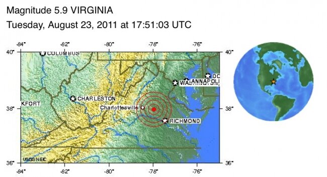
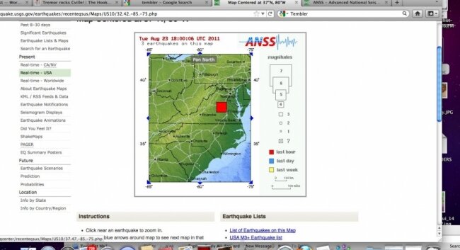
 An earthquake that measured 5.9 on the Richter magnitude scale hit Charlottesville at 1:51pmUSGS website
 -
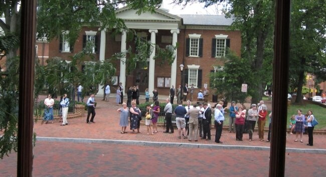
 Lawyers and other legal eagles take refuge in front of the county courthouse after the earth shook.Hawes Spencer
 -
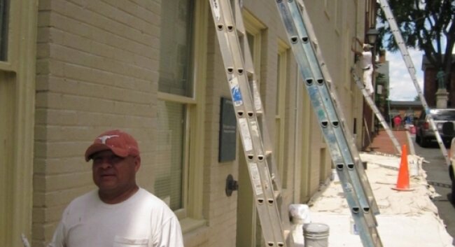
 Painting foreman Nacho Velasquez had several men on ladders at the time of the quake.Hawes Spencer
1:52pm: Whoa! We just had a long tremor/earthquake? here on the Downtown Mall just seconds ago! Stay tuned for more.
2:10pm: According to the latest information, the epicenter was between Charlottesville and Richmond, but a lot more powerful than the the one we felt in 2003 that measured 4.5. Reports are coming in that it was felt in Virginia Beach, Washington D.C., North Carolina, New York, and as far north as Canada. The quake seems to have disrupted cell phone communications as well. State Captial and General Assembly buildings were evacuated.
"I thought the Pavilion where I live was going to collapse," reports UVA professor Larry Sabato, "seriously."
2:31pm update: The USGS measures it at 5.9 on the Richter Scale and puts the epicenter about 0.1 miles underground and about four miles southwest of the town of Mineral. Hook map.
2:59pm update: The nukes at North Anna have reportedly been shut down as a safety precaution. According to Virginia Tech, this quake slightly surpasses the 5.8 intensity of the previous modern-day record-holder in Virginia: a last-day-of-May 1897 chimney-breaker that was centered in Giles County.
3:08pm correction: We initially misread the data on the depth of the quake. The depth listed above now matches the USGS report.
3:13 update: The 911 emergency telephone lines are down, so anyone needing emergency assistance should dial the administrative line: 434-977-9041. Due to high call volume, many citizens have gotten "all circuits are busy" recordings, and officials such as Charlottesville Fire Chief Charles Werner urge the public to please refrain from calling friends to gab about the quake.
3:25 update: USGS warns that the quake may be an foreshock and that "the worst may be yet to come."
3:33pm update: The USGS has downgraded the quake to a 5.8, a move that robs it of its unshared position as the most powerful quake in modern Virginia history. Meanwhile, the depth has been revised to 3.7 miles underground. The good news is that 911 lines are reportedly working again.
4:07pm update: City spokesperson Ric Barrick says that crews are checking out a reported gas line rupture on West Main Street.
53 comments
Felt it at Whole Foods. Seem to remember the last one being in 2003?
wow - never a dull day in the Ville!
Yep. We felt it near Orange at about 1:50. It seemed like a good 30 seconds.
Felt it at target
Early report: 5.8 tremor centered near Mineral between here at Short Pump.
Felt it at UVA, 30 seconds, hope everyone is okay!
Anyone's cell phone working? Briefly got through on one call but nothing since then.
We felt it in Burlington, NC
Felt it in Cape Charles!
Felt it on Long Island just as my girlfriend's (she lives in Charlottesville) text arrived telling me about it.
Felt it here in Keene. My dishes were rattling in the cabinets.
Da buildin hurr on Pantops was SHAKIN MANE!!!!
that was me guys, sorry
Felt it in Northern Labrador while blogging here ,thought it was something i said .
I just left Christ Church in NZ....and this was as strong as the ones I felt there.
Beth- my boyfriend also just left Chch to come here as well, can't seem to get away!
just got home in western massachusettes from Charlottesville to see the Dave and Tim show. We felt that earthquake all the way up here.
Sure wish I had been makin' love at the time....would have been nice to say, We rocked the world!
UMass Boston was officially closed this afternoon as a result of Virginia's earthquake. Due to aging infrastructure built upon fill, the administration felt it prudent to inspect our buildings before calling them safe for students, faculty, and staff. So, we're having the summer equivalent of a Snow Day in August. Thanks VA, for giving me the afternoon off. I miss living in C'ville none-the-less!
Earthquake devastation: http://jmckinley.posterous.com/dc-earthquake-devastation
Felt it thru my nose and my toes. Felt it thru my hair its not fair, still have to work for the medical vulture n cville
Bet this earthquake rattled some nerves at North Anna
from an earlier Hook article:
"Actual earthquake damage to North Anna is not likely, according to UVA Geology professor Thomas Biggs, who notes that while Virginia does lie atop several faults, none seem likely to spawn major quakes. In fact, he says, the several small earthquakes in the past decades– including two in 2003– have remained under 4.0 on the Richter Scale. That's enough to rattle but certainly not topple houses– or nuclear reactors. "
http://readthehook.com/89366/nuclear-nightmare-could-japan-happen-here
How far is North Anna from Charlottesville ? here's the answer
http://readthehook.com/89390/addendum-tragedy-how-far-charlottesvill...
It sounds like the systems at North Anna did exactly what they were supposed to do. Main systems shut down, back-up systems kicked in.
Good thing RWSA released the dam innundation map for their new earthen dam, and notified affected property owners. If they build that new dam could be a lot more water up there at Ragged Mt.than there is now, and a release of the 1,100 million gallons of water they keep bragging about sure would send a lot of water tumbling down the pike.
First time I've ever had a martini shaken twice at lunch.
If it had only been hotter Charlottesville could have been Shake'n Bake USA.
@kayaker: a friend of mine who lives down at Lake Monticello told me that he'd seen documentation that his house is in the flood plain if the proposed mega-dam at Ragged Mt. were to burst.
It was fun
http://www.buzzfeed.com/mjs538/stunning-photos-of-damage-caused-by-the-e...
9:23pm West Main at 9th closed to traffic
@skipwith I wonder what this earthquake will do to insurance rates of those in the RWSA Ragged Mt. Dam flood inundation zone .
Imagine the possibilities during a major earthquake that takes out roads, bridges, dams and pipelines. The Ragged Mt. Reservoir is slated to become our only water supply reservoir in 50 years if the dam planners get their way. The Plan is to have the reservoir go under I64, with water being electrically pumped uphill from South Fork, and a 45ft. earthen dam holding back the water at Ragged Mt., that the geologist on WINA this evening said, even with the best of planning, could break if the earthquake surpassed a certain magnitude.
Great Plan !
Evidently the quake occurred on a little known fault line outside of DC called "Bush's Fault
felt it in lexing ton va
Felt it in Watertown, NY
The quake lasted a lot longer than any 30 seconds. When it got too shaking the building I was in too much, I went outside, and the roaring went on and on, and I could feel it through my feet in the earth. It was more like about 2 minutes altogether.
I agree with Caesonia. It seemed to last a lot longer than 30 seconds in Earlysville. At least more than a full minute. Is it possible that it lasted different amount of time in different locations? Or is it more likely that one's perception of time may have been affected during the event? I hope others will weigh in with how long it seemed to last.
The further you get from the epicenter of a quake the flatter the shockwaves become and the smoother and longer the shaking is. Having lived in southern California for many years, I would say we were fortunate that there wasn't more damage. A 5.8 is a significant quake.
I agree that the rumbling went on longer than a minute in Earlysville and maybe as long as two minutes. My old house was shaking like crazy. Shook me up too!
p.s.
we had a little tremble in the middle of the night here in E'ville- lasted a second or so but def. earthquake related.
Why is everyone concerned about the NEW concrete dam proposed at Ragged when what you should worry about is the VERY OLD earthen dam that seems much more likely to fail in an earthquake than a modern dam would. Analogy being, during an earthquake, would you want to be in a house built in 1885 or a house built in 2011 if safety is what you care about?
Anthony, this is the problem- people who aren't paying attention making statements like the one you just did. The dam that they plan to destroy, which was studied by an international dam building firm and deemed to be sound for 100 years or more after a spillway repair and minor repairs is not an earthen dam - it is a roller compacted concrete dam with an earthen buttress. The new dam being proposed is an earthen dam - not a concrete dam . Please check your facts !
I heard a geologist hypothisizing that this was along the Spotsylvania Fault the same fault that produced tremors in 2003
PDF]
Shaken! Earthquake Rocks Central Virginia
www.wm.edu/geology/virginia/whats_new/QuakeStory.pdfSimilar
File Format: PDF/Adobe Acrobat - Quick View
Farmville. RICHMOND. Jam es River. Spotsylvania. Fau lt. Lakeside Fault ... Spotsylvania faults and the approximate location of ...
Well Anthony, I'm concerned that the new dam will have a much larger amount of water behind it and will be built by whoever gives the LOWEST bid.
Modern concrete construction is no guarantee of quality as the failure of a portion of the ceiling of Boston's "Big Dig" project illustrates. You may recognize the name of the engineering firm responsible for the design of that section, it was Gannett Fleming Inc.. Sound familiar?
Now that the Spotsylvania fault is active again ( since 2003 ) and now this larger quake, I just heard on NPR that the likelihood of an even bigger quake in this area has increased. I would be interested to know what size earth quake can the planned for new earthen dam at Ragged Mt. withstand ? With the increase of water if it does fail there is sure to be a greater loss of life.
wanting to know more - http://en.wikipedia.org/wiki/2011_Virginia_earthquake
I had no fear of yesterday's quake until I read this at Cvillenews.com:
" Dominion spokesman Jim Norvelle said in March that the plant was designed to withstand a magnitude 5.9–6.1 earthquake. We had a 5.8. In today’s Reuters article, Dominion is already upping that number, with Norvelle now saying that “the plant was designed to withstand an earthquake of up to 6.2 in magnitude "
President Obama has just renamed Mineral, Virginia- it is now called Bush's Fault, Virginia.
They just turned the earthquake machine on again!
yep, I just got another aftershock @ 1:10 am. is it still an aftershock if it's 36 hourse later?
I made one comment on this thread yesterday stating I worked for a geologist's group and did mapping for them and there definitely are faults in the area and you deleted it? For what? It was about the earthquake. It was not offensive. What's the criteria here?
Possibly,
Sorry, I don't recall deleting a comment yesterday. Why don't you go ahead and re-post it.
I guess I will check my facts better. The pictures I see from the construction in ~1885 show piles of rubble and dirt being raised into a dam, so maybe all of that is encased in concrete?
Thanks for the correction
Aha! So now we know that the author of the article gets to moderate the online comment forum on the website! I recall possibly's comment about there being fault lines in Louisa. However tectonic plates aren't colliding there, and it's more likely the "earthquakes" and "aftershocks" were from underground nukes detonated as part of the battle between the CIA trying to move their assets from Langley to Colorado in the tunnels and the U.S. Military trying to block the manuever because they know what the implications are and they have reservations about letting it go down so they set some nukes off to block the tunnel and blow some underground bases to smithereens!
I have heard it was the spotsylvania fault as well but I have also heard that it is Obama's Fault!!
get it? right? ooh nevermind....