STRANGE BUT TRUE
DRAWING BY DEBORAH DERR McCLINTOCK
Q. Imagine an "Inter-species Olympics" where the featured event is a race starting from point A on the bank of a river and ending at point B at the top of a tree miles away on the other side. The contestants must first swim a mile, then run five miles, then climb the tree. And the winner of this offbeat triathlon is...–M. Phelps
A. Surprisingly, a human being is the only species that can get there in a reasonable amount of time, says Vincent Mallette in The Science of the Summer Games. Think about it: To beat us, a fish would have to change into a horse and the horse into a monkey. "Human beings– the great 'generalists' of the animal world– have enough fishiness, horsiness, etc., to pull it off."
By the way, "Athlon" is a Greek word meaning "athletic contest." In the ancient Greek Olympics, the pentathlon consisted of throwing the discus and javelin, running, jumping and wrestling. Although the individual combat sports were the most avidly watched events, the winner of the pentathlon was revered as the supreme all-round man and embodiment of the Greek ideal. The modern pentathlon– riding, fencing, pistol shooting, swimming and running– gives athletes a chance to shine in this kind of all-around performance.
Q. Who are "the new geographers," and how are they redefining how we look at and get around in the world?–F. Magellen
A. Digital maps are booming, two-dimensional computerized representations of the world that are generating scores of new words and phrases, says Paul McFedries in IEEE Spectrum magazine. Beyond MapQuest and Google Maps and Yahoo Maps are "base maps," starting points for more detailed "map mashups" to guide people to locations of rental apartments, weather, or traffic data, etc. "Virtual globetrotting" and "virtual tourism" are possible too for anyone wanting to see the world while dodging the agony of airline food.
Digital cameras now come with built-in Global Positioning System (GPS) receivers that note the exact longitude and latitude of each picture taken, data that are readable by map services, called neogeography. Neocartographers and companies are also making newfangled map worlds; for example, there is software for analyzing the text of a book to extract all the place names and plot them on a map. Location-aware devices such as GPS-enabled mobile phones can display a map of the user's current location, known as "mobile augmented reality." In "geocaching," scavenger hunters receive the geographical coordinates of a cache of items and then use GPS and other such "geotools" to locate them.
It goes on and on. "With all this digital mapmaking activity, you can see that maps and atlases printed on [scoff!] paper are so last century."
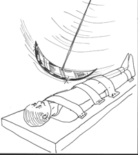
Q. In Edgar Allan Poe's masterpiece of terror, The Pit and the Pendulum, a prisoner finds himself strapped beneath a large pendulum hanging some 30-40 feet above, apparently motionless. But later he notices it is swinging by about a yard and is descending. "Down–certainly, relentlessly down!" To his horror, he realizes the lower edge consists of a "crescent of glittering steel," sharp as a razor. Agonizing hours go by and the blade continues its descent, swinging up to 30 feet or more. And it is aimed directly at his heart! Now for a question regarding the mechanics of such a torture: Supposing the blade were suspended by a rope that was slowly let out, why would the extent of the swinging increase?–S. King
A. Because when the crescent was initially lifted up, it gained potential energy with height but as the blade was slowly lowered, the potential energy was converted into kinetic (swinging) energy, says Jearl Walker in The Flying Circus of Physics. Although Poe miscalculated the amount of swing– it should have been more like 10 feet than 30 feet– "still, the mathematical inconsistency would hardly be any comfort to the prisoner in Poe's tale."
~
Send strange questions to brothers Bill and Rich at [email protected].
#