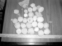
Hail, yeah: Tornadic possibility in Western Albemarle
After a pair of bruising storms that brought hail and high winds, some residents could be forgiven for wondering if they're living in storm central.
While a huge storm limbed trees on June 4, Waldo Jaquith limned an account of a tornado on his website. Visitors to www.cvillenews.com got to read Jaquith's minute-by-minute accounts of rumbling winds, snapping branches, and "monster sized" hail.
On June 18, the storm was smaller and more localized– more hail, downed trees on Garth Road, and zesty rain and lighting downtown.
The good news: auto glass and body shops had a business bonanza. The bad news: we really might be living in a bit of tornado zone.
Two years ago, a tornado struck Ivy and Farmington. Although rated an F1, the weakest on the scale, it was enough to uproot giant oaks and cause severe structure damage. More serious were the 1922 Crozet tornado that smashed several farm buildings– and the 1959 Ivy tornado that killed 11, 10 of them in one house.
According to state climatologist Patrick Michaels, hail and tornados are part of "the same concept." Whenever a storm crosses a mountain range that suddenly drops down to lower land, it has the tendency to stretch out its height. If such a storm is rotating, like the swirl of bathtub drain, a tornado is possible.
"Theoretically, it makes sense," says Michaels, of the idea that Afton/Crozet/Ivy area could be a tornado zone. This, he says, is a smaller version of Northeastern Colorado, where the Front Range of the Rocky Mountains suddenly loses more than a mile of altitude to the Colorado plains. While the fall from the Blue Ridge to the Piedmont is only half a mile, the effect could be similar, Michaels theorizes.
"It's one of those things that should be true," says Michaels, "but it hasn't been scientifically proven."
Intrigued by a reporter's question, Michaels vowed to contact the North Carolina climatologist to "chew the fat."
